LINCOLN, Neb. (KOLN) - Hope your snowblowers are all gassed up and ready to go - a potentially major winter storm could impact the area as we head into the day on Monday with another round of light to moderate snow expected on Tuesday into early on Wednesday before Mother Nature finally relents and gives us some quiet weather for the second half of the week next week.
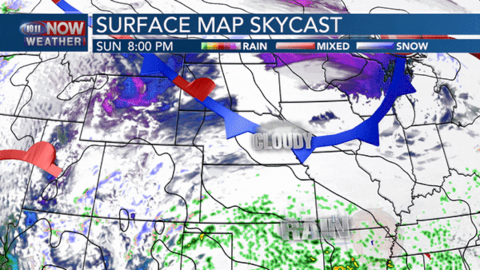
While snow has ended on Saturday afternoon, Winter Weather Advisories are in place across the state through late Saturday night into Sunday morning as areas of freezing drizzle will likely continue to keep slick travel conditions in play. If you’re out and about Saturday night or early on Sunday, watch out for slick spots and take it slow.

Not much is expected to happen on Sunday as we wait for our next winter storm to impact the area. It will likely be a cloudy and colder day with highs in the upper 20s to upper 30s across the state with wind chills in the upper teens to upper 20s by the afternoon.


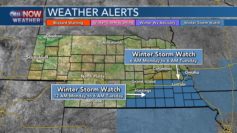
Winter Storm Watches are in place across south central and southeastern Nebraska for the day on Monday and into early Tuesday morning. These areas - including Lincoln and Omaha - have the highest potential for some significant snowfall accumulations through this time frame.
A strong low pressure system is forecast to track just to the southeast of the Kansas City area, which would south central and southeastern Nebraska in the favored zone for potentially heavy snow through the day on Monday. We’re expecting moisture to surge northward Sunday night into early on Monday with snow showers, potentially mixed with some freezing drizzle or freezing rain to start Monday before any precipitation will turn over to all snow through Monday morning. Snow intensity should peak through the morning into Monday afternoon, and we could see snowfall rates of 1″ to 2″ per hour at times. We could even have some thundersnow across the area as there is a least some instability forecast with this system.
Wet, heavy snow will continue through most of the day on Monday with snow even lingering into early on Tuesday. Total snowfall amounts will be highest in the southeastern corner of the state, where they could see 8″ to 12″ of snow. For Lincoln and the surrounding area, the going forecast as of now, is for 4″ to 8″ of wet, heavy snow. Further to the north and northwest, snowfall amounts should drop off fairly quickly.

It should be said, that this initial snowfall forecast is on the conservative side. Depending the track of the low pressure system, that band of heavy snow could shift either further north or south. Please do not let this be the last time you check the forecast. Make sure you stay tuned through the day on Sunday for more updates.
Another round of light to moderate snow is possible Tuesday evening into early on Wednesday that could drop a few more inches of snow across the area. The weather should quiet down considerably for the second half of the week into next weekend.
Copyright 2021 KOLN. All rights reserved.
"day" - Google News
January 24, 2021 at 06:19AM
https://ift.tt/2Y7yKEb
Powerful winter storm to impact the area into the day on Monday... - KOLN
"day" - Google News
https://ift.tt/3f7h3fo
https://ift.tt/2VYSiKW
Bagikan Berita Ini


0 Response to "Powerful winter storm to impact the area into the day on Monday... - KOLN"
Post a Comment