It already feels like summer across parts of the US, with record-breaking heat expected from New Jersey through North Carolina on Wednesday. High temperatures will surge back into the 90s following an early-week cool down.
New York City only reached 68 degrees on Monday, which is 5 degrees below average. Wednesday, the thermometer will likely hit 90 degrees, making for a significant warmup.
The rest of the Northeast will have temperatures 15 to 20 degrees warmer than the typical temperature for this time of year. The Southeast will be hot as well in the mid to upper 90s. Some locations could hit 100 degrees. That is generally 10 degrees above average.
But changes are on the way for the weekend.
"If you're making weekend plans based on the summer-like temperatures we are seeing now, check your local forecast. Most of the Northeast and Midwest will cool down 20-30 degrees over the weekend and we will actually see below normal temperatures," said CNN Senior Meteorologist Dave Hennen.
Wet and cool start in the Northeast
The Mid-Atlantic is in for a drab start to the weekend in terms of the weather as a storm system tracks through, bringing rain showers, thunderstorms and rather chilly temperatures.
Washington, Philadelphia, Baltimore, Pittsburgh, Richmond and Raleigh could all see showers and storms passing through on Saturday. The New York City area will likely deal with clouds and the chance for a shower while New England is expected to be generally dry with partly sunny skies.
Temperatures will be 10 to 15 degrees below average on Saturday, translating to highs only in the 60s for most locations. Jackets may be needed after the shorts and t-shirt weather earlier this week.
The good news is a gradual warmup is in store for Sunday and Monday. Temperatures will remain below average on Sunday but then near normal on Monday for Memorial Day, with highs back into the 70s by the end of the extended weekend.

High pressure will move south from Canada for Sunday and Monday, providing partly cloudy skies and dry conditions for most, making for nice conditions to host outdoor activities.
Cooler temperatures for Southeast too
While the Northeast will experience a substantial cool down this weekend, the Southeast will also witness falling temperatures too but will instead return to near average.
Saturday will still be mild in the Southeast, with temperatures near 5 degrees above average. A couple cities could break their daily record high temperature in central Florida as highs reach the mid 90s.
There will be the chance for a few showers and thunderstorms, however, especially near the Gulf and Carolina coasts on Saturday.
Sunday will likely be the driest day overall in the Southeast with the sun shining, making for a perfect pool day. Portions of the Florida Peninsula may contend with an afternoon thunderstorm ahead of a cold front, which essentially divides the hot and mild air masses.
Temperatures will be rather seasonable too on Sunday, except for the Carolinas which will have high temperatures around 5 degrees below normal.
Memorial Day will be similar to Sunday. Temperatures will be a few degrees warmer than Sunday in the Gulf Coast states. Most locations will have highs range from the mid 80s to low 90s on Monday. The risk for passing thunderstorms will continue in Florida.
Strong storms in the Plains
Temperatures will also be below average in the Plains and Midwest, but will be on the cool side through the duration of the holiday weekend.
Thunderstorms and showers can be to blame as a new storm system slowly forms near the Front Range of the Rocky Mountains. This will cause rounds of storms, similar to the weather already this week.
There is also the risk for severe thunderstorms, with tornadoes, damaging winds and large hail all possible, although it is too early to determine how significant the threat is at this time.
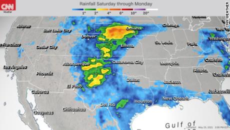
Rain is most likely Saturday across portions of Texas up through western Nebraska. The radar will become more active and widespread on Sunday across similar areas, especially closer to the mountains and higher elevations.
Storms will remain possible from the Front Range through the Central Plains, with the risk for showers extending into parts of the Midwest.
Flooding or ponding will be possible, with 2 to 4 inches of rainfall currently forecast in some locations this weekend.
Rising temperatures in the West
Temperatures will be rather split across the US this weekend, with cooler than normal readings for the East and above average temperatures in the West overall.

A building ridge in the jet stream wind pattern will force warmer temperatures further north and up the West Coast. Saturday will be the coolest day out of the weekend but highs will still be 5 to 10 degrees above normal across the Southwest and interior coastal regions.
The interior Northwest will still feel temperatures slightly below average Saturday but that will change for the rest of the weekend.
The mild air will shift from the Southwest to the Northwest, with highs up to 20 degrees above the typical temperature for late-May from northern California through Washington state.
The dry weather will accompany the warmth, making for ideal weather for outdoor plans with only a few clouds dotting the sky.
"day" - Google News
May 26, 2021 at 04:36PM
https://ift.tt/3vtQoRS
Northeast experiences cool and rainy start to Memorial Day Weekend, while summer is in full gear elsewhere - CNN
"day" - Google News
https://ift.tt/3f7h3fo
https://ift.tt/2VYSiKW
Bagikan Berita Ini


0 Response to "Northeast experiences cool and rainy start to Memorial Day Weekend, while summer is in full gear elsewhere - CNN"
Post a Comment